09 Nights / 10 Days
Hard Trek
13,715 ft
July to Sept
Kashmir
Srinagar Airport
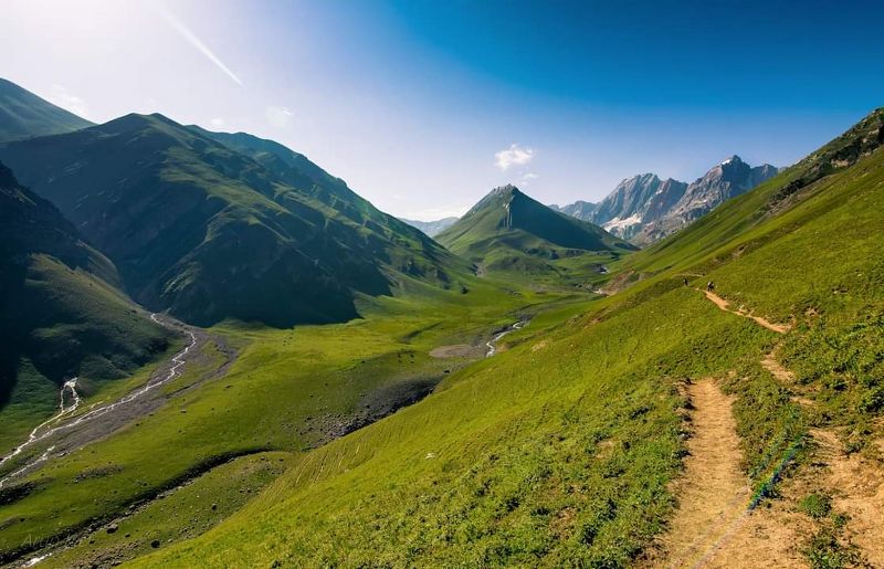
Kashmir Great Lakes is one of the most beautiful treks in India. No question. It validates Kashmir’s mythical status as heaven on earth.
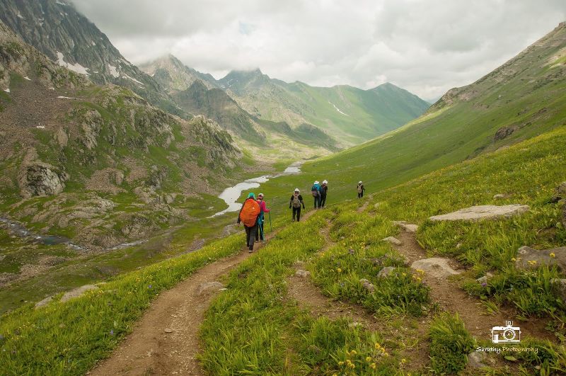
This is because the trek is set on a canvas that’s larger than life. It is situated 75 km northeast of Srinagar. Every day is a 360° panorama of wild, rugged mountains, rolling meadows, and turquoise alpine lakes. And you get more than six of these lakes and five very different valleys to explore!
The range of landscape makes it a moderate-difficult trek spanning over six days. This means it has long trekking days with steep ascents and descents with no easy exit points. So, it’s not meant for a beginner who hasn’t been exposed to high-altitude treks.
After this trek, every other trek feels as though it is a movie on a small screen. Kashmir Great Lakes, however, is an IMAX 3D experience – such is the grandeur of the trek. If you have not done this trek, put it on your bucket list!
Best Time to Do Kashmir Great Lakes Trek
The right time to do this trek is from 1st week of July to the last week of September. Especially in the months of June, green and colorful meadows (bugiyals), snow is found in abundance here, which makes your trek very memorable.
This season brings up many questions in the mind of a trekker. Primarily, because it is monsoon in the rest of the country. Will it rain heavily on the trek? Well, most trails in Uttarakhand are shut during this time. But things are different in Kashmir.
If you observe the map, you see the Pir Panjal range separating Kashmir from the rest of the Indian subcontinent. This range is 288 km long and 40-50 km wide. It blocks most rain clouds from crossing over into the Kashmir Valley.
This divide determines the nature of precipitation and the vegetation in this rain shadow area. All of which stand very different from the rest of the country.
July to September happens to be peak summer transitioning to Autumn and the best time to trek in Kashmir. The landscape comes alive during this window. And even though the window is tight, you notice the landscape changing colour and texture as the months proceed.
During the day the temperature of Kashmir Great Lakes trek is around (05°C to 18 °C) and during the night the temperature comes down to (03 °C to 08 °C).
How difficult is Kashmir Great Lakes Trek?
Kashmir great lakes trek is a very beautiful and a hard trek in the Kashmir valley. Kashmir Great Lakes trek is great for those people who have a great passion for mountaineering.
Although, we have listed this trek under ‘Hard Trek’ but if your fitness is good and you have it in your mind that I want to trek then you can do it absolutely.
Coming to the details, you cover a total of 75 km in six days. On average you will trek 12 km every day. The trek also makes you climb 1500 feet and descend 1500 feet every single day.
There are 3 difficult sections on this trek:
➤ Special Cancellation Policy for Kashmir Treks: Because of a govt. order in Kashmir, we have extremely limited slots for the Kashmir Great Lakes trek. This has increased the demand for the trek. Which is why we have a special cancellation policy for this trek. It is designed to help trekkers take an early call about their trek.
If you cancel your trek between 60 days to 1 day of the trek, you do not get any refund or a voucher. You forfeit your entire trek fee.
If you cancel the trek over 60 days before the trek date, you get a refund with 10% cancellation charges.
➤Advisory Note: There are often uncertainties regarding trekking in Kashmir. If you’re planning any trek in Kashmir, ensure you book flexible flight tickets that allow you to reschedule your flight at no added costs. These are readily available with most airlines.
➤Unforseen Changes: In case of emergencies, we will reroute treks to other trails. Please ensure you’re mentally prepared in case such situations arise.
For all your travel plans, include a buffer day to accommodate bad weather on the trek/political instability. This depends entirely on the circumstances of the trek and the situation in Kashmir.
➤Documents required: It is mandatory for trekkers to carry a photocopy of their photo id along with the mandatory documents of the Medical Certificate and Disclaimer form. This is required for trek permissions before and during the trek.
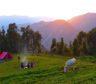
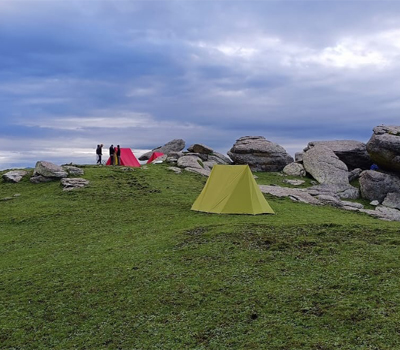
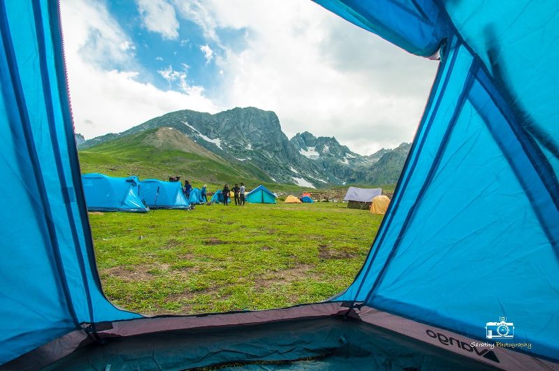
➤Stay facility: You will be staying in tents on all days of the trek.
Please note: You will have to reach Srinagar a day before and meet the Himalayan Memories team at Srinagar. The process of your registration, health screening, and document verification will take place there only. This is the same place where your rental gear collection will also happen.
On the first day of your arrival, we will receive you at Srinagar Airport & take you to hotel. Check-in & rest for the day.
The process of your registration, health screening, and document verification will take place at Srinagar only. Our Trek Leader will help you with all these. If you reach early, you may go for a local sightseeing tour (extra chargeable). Overnight stay at hotel in Srinagar.
Drive Duration: 2-3 hours || Drive Distance: 50-60 km || Trek distance: 12-13 km || Trek Duration: 7-8 hours
The trek starts 3 km out of Sonamarg (7780 ft), on the Srinagar road. Exactly at the 3 km mark, you will spot a lone Dhaba on the right. The place sells packaged water, biscuits and other edibles and is your last place to pick up short eats. The next trace of civilization is only at Naranag, where the trek ends. Today’s trek consists of a 3 hours ascent followed by a 1 to 2 hours descent and finally a gentle 3 hours ascent to Nichnai.
On the way, we will find a beautiful meadow surrounded by Bhoj trees. The place is locally named as Shekdur. We will have lunch here before moving ahead to Nichnai.
The trail after Nichnai is now along the right bank of the river going upstream. Look behind to see snow-clad peaks from Sonamarg valley. You are now in a wide valley but enclosed by mountains on either side. The river, which joins the Sindh eventually, flows in speed through the valley. The first 30 minutes is over the rocks and your mules will walk very slowly over here. The river valley widens and you can see the green meadow widening in between the two mountain ranges. Far ahead lie triangular twin snow-clad peaks. Choose a flat ground to pitch tents and end the first day’s trek.
Trek distance: 14-15 km || Trek Duration: 7-9 hours || Altitude gain: 11,900 ft to 12,055 ft via 13,230 ft
The day’s trek is a long walk on meadows with the scenery changing for the better all along. Your first milestone for the day is the Nichnai Pass. The pass is visible at a distance from the camp site. It lies just to the right of the twin snow-clad peaks. It is a medium climb to Nichnai Pass, 13,230 ft. As you climb, notice a small lake at the foot of the mountains. It is a deep blue lake and you can sense your expectations rising with regards to the lake. This is the last point on the trek where you get a phone network. The next sign of network is only when you move beyond Gangabal.
The Nichnai Pass feels like a wide tunnel. On the left stand a series of snow-clad peaks. There are no peaks on the right but the land raises on the right too. Stop here and take a view of the peaks, the river below and the flowery meadow. Notice to your left a big waterfall splashing down the mountain cliff and joining the river. From the waterfall, the rapid descent ends and you are now walking through the flat wide meadow. On the left are the classic snow-clad Himalayan mountains but notice on your right, grey and barren mountains resembling the Ladakh ranges.
Walk along, in between the two ranges, over the lush green carpet of grass until you reach the end of the valley. Another stream flows perpendicularly from your left to your right. This stream originates at the Vishnusar lake which is a bit higher on your left. The lake is not seen yet and cannot be seen from the camp site. Pitch your tents anywhere besides the stream coming from the lake. There is ample camping space.
If you get some time you can explore the twin lakes now.
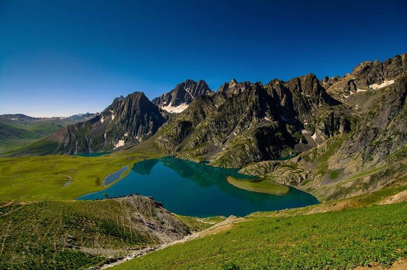
The Vishnusar lake lies 0.5 km to the left and 100 feet above the camp site. The next lake in the series is Kishansar. This lies about 0.5 km away and 500 feet higher than Vishnusar. The Kishansar lake lies at the base of the Kishansar peak. It takes about 45 minutes to reach Kishansar lake from the camp site.
We camp for the night at Vishnusar Lake.
Trek distance: 16-18 km || Trek Duration: 8-10 hours || Altitude gain and loss: 12,055 ft to 10,800 ft via 13,715 ft
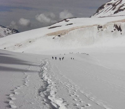
The next part of the trek is from Kishansar lake side to the top of the ridge. You see a pencil thin line traversing through the mountain side. That is your track to follow. The view of the twin lakes lasts till you reach the ridge top or the Pass. This is called the Gadsar Pass – altitude 13,715 ft – the highest point on this trek. The trek is a steep 4-hour ascent followed by a steep descent in the meadows. On the other side of the Gadsar Pass stretches a long valley with 2-3 small lakes visible. Far in the distance lie a series of snow-clad peaks. The peaks lie outside our Line of Control. It is not uncommon to find snow at the Gadsar Pass and also in the initial parts of the descent to the other side.
When you are in the blue Iris area, you are almost at Gadsar – one of the prettiest and most pristine of the lakes on this trek. Gadsar is at the base of snow-clad cliffs. Blue flowers spring up on one side and snow slabs fall into the lake from the mountain on the other side.
You will find few shepherds’ huts & little downhill takes you to Gadsar army camp. One needs permission from their Headquarters. The Headquarters is 4.8 km further away down into the tree line near a village. The Gadsar camp communicates with the HQ through walkie-talkies. The HQ is equipped with a satellite phone for the army. If you are near the Gadsar army camp, it is best to report to them as soon as possible. It takes 2-3 hours for their green signal to come through. All details of the trekkers and staff, including original identity cards, are recorded, collected and checked.
Trek distance: 12-13 km || Trek Duration: 6-8 hours || Altitude gain: 10,800 ft to 12,100 ft
Having already covered the first three day, we move ahead to the next campsite. Fourth day trek is from Gadsar to Satsar. First two days of trek were without passing through any lakes but next two days were all about lakes. Third day, we passes as many as five lakes on the way including big ones like Vishnusar, Kishansar and Gadsar. This fourth day was also all about lakes. Actually name of the next campsite is Satsar which means seven lakes.
The altitude for the day hovered around 12000 feet. Trek starts by crossing a glacier and there is small climb after that. Be it small, but it was first glacier to be crossed on the trek.
rek thereafter is gradual and quite beautiful. It was a small climb though initially followed by a gentle ascend along the hillside. The climb goes on becoming smoother as we pass through a ridge covered with lush green meadows.
Second half of the day’s trek passes through a stream and than a couple of lakes. Once we leave this ridge and river valley and turn left we come across a large plateau with mountains to the left and a stream flowing on the right.
Calm and cool water of lake tempted a few of us to take a dip, but this isn’t advisable for all as the water is too cold and bodies are quite hot after a long trek. Jus be careful. This first lake also has a plenty of place for camping and the surroundings are quite picturesque. But we still have some trek left before reaching our campsite. Trek further is bit tricky as there are a few ups and downs through rocky boulders on either sides of the lakes that we come across. Purportedly there are four to five lakes in a series on the route, all connected to each other.
As soon as we cross last of the lake on this route, we have a small descent to the campsite on the right.
Today is the day we rest. We can even use this day anywhere in between the trail. That depends on your physical condition at that time which our Trek Guide will decide.
Satsar is actually a collection of 7 lakes. You can find 4 or 5 lakes with water, depending on the season. Beyond the ridge, on the right, is the Satsar army check post. It is the 3rd line of defense from the LOC. The same process of identity checking, collection and questioning repeats here. Save as much energy as you can, so that tomorrow is a clean day of trekking. 10 to 15 minutes out of the army camp is the first of the Satsar lakes. The lake is pretty big and looks picturesque in its green setting with mountains in front.
We will explore full day & stay at Satsar only.
Trek distance: 9-11 km || Trek Duration: 6-8 hours || Altitude loss: 12,100 ft to 11,500 ft via 13,276 ft
After all these days of trek, it’s time to move towards the climax of the Kashmir Great Lakes Trek. It was supposed to be the last day of climb. Satsar campsite is at an altitude of 12,100 ft and Gangabal campsite is at a an altitude of 11,500 ft but on the way we have to cross the Zaj Pass at an altitude of 13,276 ft.
Its climb right from the word- go. A steep fall on the left and cliff on the right. You will have to cross through boulders and loose rocks. Contemplating the moves! Looks like another peak to climb!! The ridge at the top is the Zaj Pass, the last high pass of the trek. It would be all down after that.
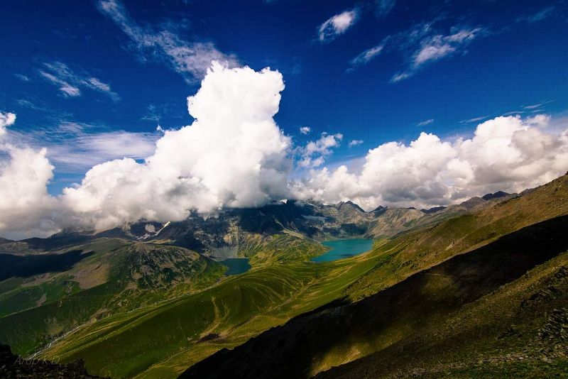
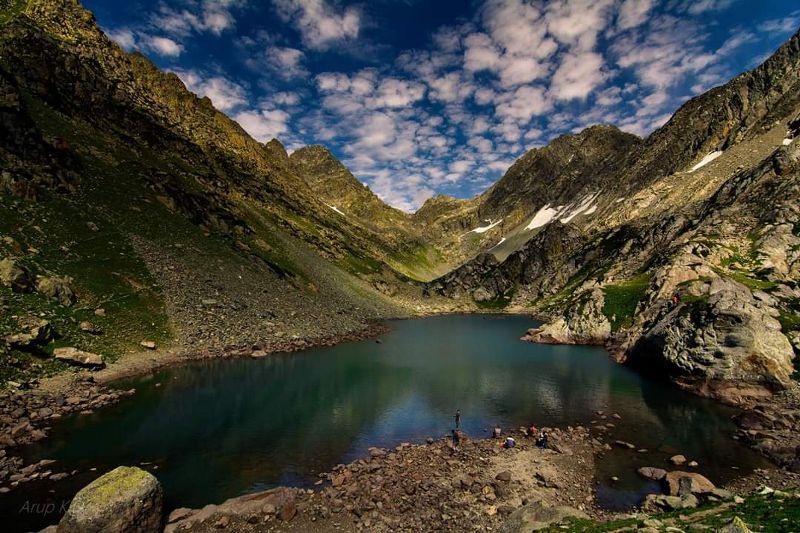
The best part, however, is the surprise view you get from the ridge top. The two lakes lie next to one another, Gangabal & Nandkol. A quick climb, a shorter descent and a stream crossing over a wooden log bridge brings you to the shores of Nandkol lake.
The Nandkol lake lies at the base of the Harmukh peak. The Harmukh glacier hangs on the sides of the rocky edges of the mountain. Both the Gangabal and Nandkol are famous for trout fishing. The Gangabal lake is about 20 minutes away from Nandkol. Gangabal is huge. A parikrama of either of the lakes will easily take an hour.
We finally rest at Gangabal for the night.
Trek distance: 13-15 km || Trek Duration: 6-8 hours || Altitude loss: 11,500 ft to 7,800 ft
Drive Distance: 2-3 hours || Drive Duration: 50-60 km
The day’s trek is a killer on your toes and knees, it is a gradual descent followed by a steep descent. From the Gangabal camp site head down along the stream towards the tree line. An hour out of the camp site, you hit the fringes of the tree line. Pine trees line the meadows and you also see traces of civilization with the presence of a log hut. As a trademark of this trek, you don’t lose altitude now but start to climb up a bit. You drop to 10,800 ft at the tree line but climb again to 11,000 ft. Only after walking for 2/3 of the distance does the true descent begin. The descent is now really steep. The trail is a well-trodden, muddy one through the thick of the pines. The last 4 km see you dropping more than 3,000 ft. It is not rare to spot a lot of people trekking up here from Naranag, headed to Gangabal. The last stretch of the last day does become an endurance test but soon the stone-paved village track comes up and in no time you enter the main road of Naranag. Your trek ends here.
Wait for our car to take you all to Srinagar. Check-in hotel rooms & enjoy your must awaited bath.
Today is the day to spend at Srinagar. Explore one of the most beautiful tourist place in the earth… The Dal Lake.
When Shammi Kapoor versed the lyrics of “Taarif Karoon Kya Uski Jisne Tumhe Banaya” for Sharmila Tagore in “Kashmir Ki Kali”, he most certainly meant it for this amazing Dal lake in Srinagar too. This huge spread of dazzling water, right next to an urban city and the sight of the gondola-styled Shikaras swiftly cutting through the calm waters is indeed mesmerizing and praiseworthy.
Now, imagine being on this Shikara, taking you across the splendid Dal jheel, inhaling in the fresh mountainous air, and enjoying the captivating, mist-covered Pir Panjal ranges while the urban city of Srinagar drifts afar. What could be better than this?
At times, you will even come across floating markets, a specialty of this place, ready to sell items on the float!
The second largest lake, right after the Pangong Tso, Dal Lake in Kashmir is located in the Union Territory of Jammu and Kashmir, in the beautiful city of Srinagar, the summer capital of the same. The Dal jheel is a large stretch of water around the city of Srinagar and is surrounded by the magnificent Pir Panjal mountains. Often dubbed as the “Jewel in the crown of Kashmir”, this lake offers tantalizing views that will make you go awe.
After breakfast, check-out from hotel & get ready to be dropped at Srinagar Airport.
+91 7604030342 / 7604030349
hmdesk@himalayanmemories.com
