09 Nights / 10 Days
Moderate Trek
15,100 ft
April to May & Oct to Nov
West Sikkim
Yuksom
The biggest reason to do the Goechala trek is the grand views of big mountains that you see. You don’t just see one summit — the Kanchenjunga, but 14 other big summits too. That’s a lot for any trek — especially as close to the eyes as on the Goechala trek. It is no wonder that trekkers consider Goechala to be the closest to the big mountain treks of Sikkim.
Sunrise on the Kanchenjunga Range – One of the biggest highlights of the Goechala trek is the sunrise seen on the Kanchenjunga range. Even though trekkers are not allowed all the way to the actual Goecha Pass, the view from View Point 1 and Dzongri is worth an arm and a leg!
Rhododendrons in March to May – The trail to Goechala is blessed with rhododendron forests. And come spring months of March and April, they burst to life with pink and red flowers! It’s an enormously pleasing walk through the wooden-log trails of these jungles!
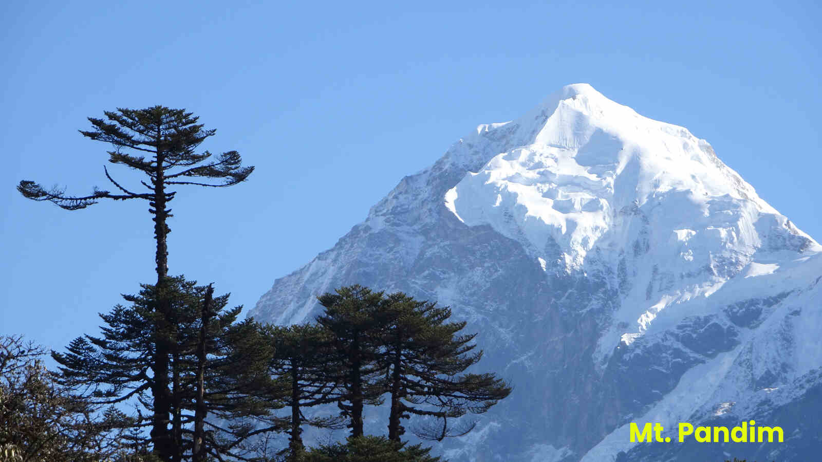
The Samiti Lake – The Samiti Lake is another big attraction on the Goechala trek. The view of the still waters, and the reflection of Mt Pandim in the lake, especially in the early hours, is a visual treat.
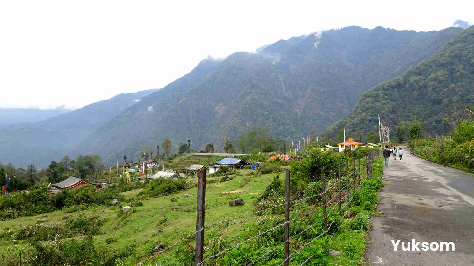
The Goechala trek starts at Yuksom, a fairly large settlement in West Sikkim. There are two things that you need to do at Yuksom before the trek begins. One, make an entry at the police station. For this you need a photo identity proof with 3 photo copies. Two, you need to pay the permit fees at the forest check post (trekkers do this in the morning when they are starting the trek). The fee to be paid is broken down into small elements like tent, porter, yak and other charges. Camera charges are extra & to be paid directly. Our Trek Leader will arrange all these for you. If you’re a foreigner, different rules apply. The details are mentioned below –
Permits required for the Goechala trek for Foreigners –
Drive from NJP Railway Station/Bagdogra Airport to Yuksom. Both the airport and the railway station connect Siliguri, which is the Gateway of Sikkim, Darjeeling and many more tourist destinations of North Bengal. It is also the transit point for air, road and rail traffic to the neighboring countries of Nepal, Bhutan and Bangladesh.
The trail, though passing through the fringes of the forest is exposed for about 30 mins. Midway through the exposed trail, look for a shelter on your right. From here onwards it is half hour to the first bridge over the Pha Khola. By the time the trail gets to Pha Khola, you are well into the thick forest and the coolness envelopes you at all times. The gently undulating trail climbs gradually.
The next hour and half is a pleasant walk through the moist jungle until suddenly on your left the Tshushay Khola falls in a series of mini waterfalls joining the Prek below. 50 meters later a large iron bridge spans the Tshushay Khola. After the bridge the trail begins to climb more noticeably.
An hour later, watch for another small cement bridge over the Mentogang Khola (you won’t find a board telling you the name). You are already at 7,100 feet and it is only twenty minutes from here to the log hut of Sachen. Sachen at 7,200 feet is a small clearing where a single log hut and a shelter on the trail exist. The log hut a few meters below the trail. The hut has room enough for about 6-7 and a small area to cook. For a larger team, look for the clearing just above the trail opposite the shelter. The Prek, runs below campsite and is not visible to the eye, though you can hear it faintly rushing below.
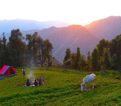
With a well-deserved rest, start your climb to Tshoka. Follow the trail just behind the Forest Rest House. At over 9,000 feet high, rhododendron trees abound everywhere. The trail gets dark from the overhanging trees and meanders for another half an hour. It suddenly pops out to a plateau and the trekkers hut of Tshoka. There’s also a flat camping area to the left of the trekkers hut. The trekker’s hut is a pretty long wooden building that has four rooms – enough space to house more than 20 trekkers. Spend some time exploring Tshoka. Slightly uphill are the cafes where trekkers can try the local malt beer Tumba. There are just a handful of Tibetan families living here in Tsoka. What will take your breath away is the view of the snow-clad peaks of the Kanchenjunga range stretching right behind you – with Mt. Pandim dominating the skyline. For most trekkers this is the view of the day.
We will climb a little higher following the log path which gives way to a regular stony trail that climbs quickly to Phedang in about an hour. Phedang, at 13,000 feet, is a large clearing with superb views of the snow-clad mountains. A log hut and a few wooden benches dot the landscape. Camp here for the day.
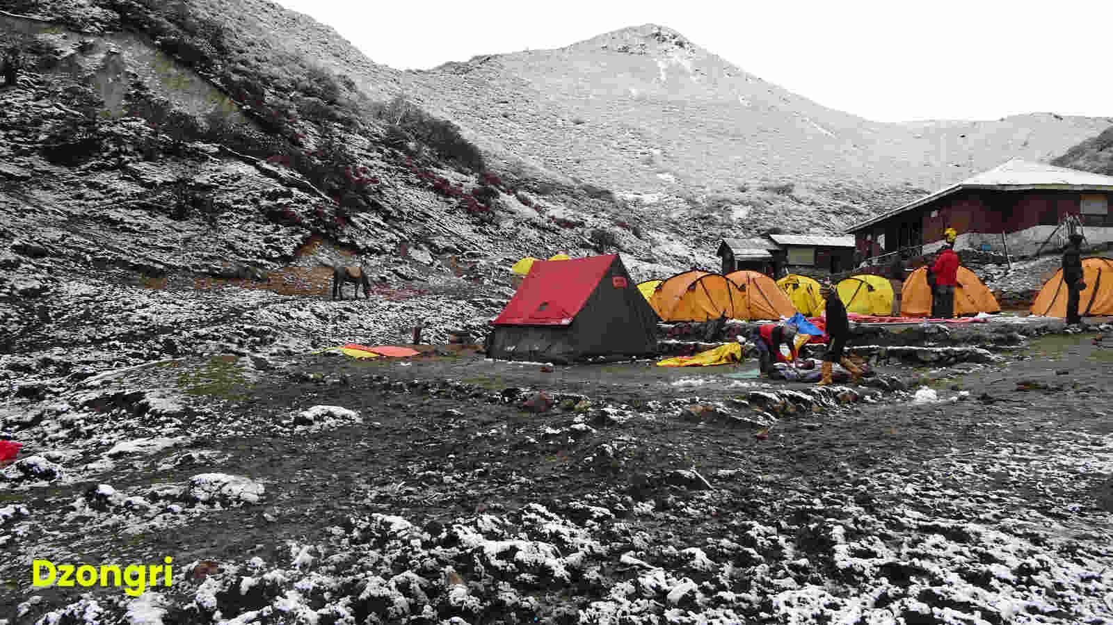
Watch for the view change between the Pandim ranges and the Kabru while you gradually climb higher from Phedang to Dzongri. An hour later, the climb tops at a shrine with multitude of prayer flags. This is the highest point of the days trek at 13,080 feet. Take a brief rest at the shrine and follow the trail that gently descends towards Dzongri. For most parts the trail undulates with the first patches of snow lining the roots of the dwarf rhododendrons around you. The Dzongri trekkers hut appears suddenly at the bend in the trail. A gentle clear stream runs by the side of the hut. There are plenty of camping grounds around Dzongri but the hut itself can take in 30 trekkers at a time. Dzongri is a welcome sight for trekkers after the hard climb from Tshoka. At 12,980 feet trekkers feel the effect of altitude at the Dzongri meadows. Dzongri is a large cauldron, mostly meadows, surrounded in all directions by the mighty peaks of the Kanchenjunga range. In every direction is a snow peak to be looked at and admired. For most trekkers Dzongri is a reward on its own. Many finish their trek at Dzongri and head back the way they came.
The day starts with a climb to Dzongri top. Dzongri top i.e at 13,778 ft, is the highest point from where you get the 180-degree panoramic view of the mighty peaks of the Singalila and Kanchenjunga ranges. Dzongri top is a two hill climb from the Dzongri trekkers hut. The trek from Dzongri-to-Dzongri top takes about 45 mins. The sun rises at 5 am and you don’t want to miss seeing the first rays of sun hitting Kangchenjunga. Start your trek at 4.00 a.m with torch lights and you reach the top just as the dawn breaks.
After breakfast, we start trekking towards Kockchurang. In half an hour, rhododendron shrubs occupy the slopes again. The gentle to medium descent continues over 2 hours. The rhododendron shrubs suddenly give way to rhododendron forest. The descent becomes steep and you lose more than 500 ft. The forest is a good place to spot birds. Walk through silently and spot birds camouflaged in the browns and greens of the forest. Kockchurang springs up at the end of the descent. Kokchurang has a trekker hut with Prekchu River flowing beside it.
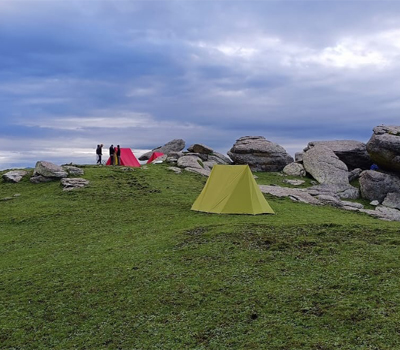
From Kokchurang, walk down to the bridge across Prekchu. Spend some time on the bridge experiencing the cool breeze of the river. The water below looks icy blue. On the other bank, you have the rhododendron forest again. They flower in June but at any time, the moss lined trees with their branches spreading out in all directions make it a fairy tale walk. There is a trekking trail but no lined path. The gradient increases and it is an ascent throughout. The distance between the bridge and Thansing is 2 Km. By midway forests end and the landscape becomes rocky and barren. At the end of the climb is Thansing– a big meadow. There is a dilapidated trekker hut at the entrance of the flat meadow. The hut is now used as a kitchen. The open meadow can host any number of tents. You are right in front of Pandim and the left wall of Kangchenjunga here. Thansing can be cold in the night. So be ready with all warm clothes what you have. Camp here for the day.
The next day trekking schedule comprises of travelling to Lamuney which is based at an altitude of 13,743 feet and it takes about three to four hours to reach the destination. The trekking schedule, for the day is quite relaxing so the morning call comes at 8.00 with breakfast at 9.00 and scheduled departure set at 10 am. Today the trekking activity is the easiest one and more of fun than being tiring.
The road towards Lamuney as expected is quite sober along the meadows with over stretched pastures on both sides, that looks simply mind blowing. The trail to Lamuney is quite decent though close to campsite the trekkers get a hard time with the steep rocky climb to move forward. On reaching Lamuney, hikers can cherish the hot lunch and relax in the fascinating ambiance. For the enthusiasts however, there remains more adventure to explore. At a distance of nearly 2 kms from the campsite lies the beautiful Samiti Lake waiting to be explored. The distance from Lamuney campsite to the Lake can easily be covered by an hour walk but the trail is not so smooth and covered with stones and pebbles. Camping beside the lake is not allowed but trekkers can surely visit the location, enjoy its fascinating beauty and come back to the base before night falls. The sight of the lake is quite mesmerizing with gushing crystal clear flowing high and hitting the hard rocks at the banks. Photography can be enjoyed here a lot with all those alluring pictorial sights, just waiting to be captured in the camera.
At the campsite, our Trek Guide will give small briefings about the big day tomorrow, and what needs to be followed before reaching the destination. The nature of the trail and what to expect will be stated way ahead. In the night enjoy the sparkling clear sky and the beautiful array of stars looking so bright yet so far at such an altitude. It is advisable to call in, it a day early, and fetch good sleep as the next day should be started in the early hours (almost at midnight).
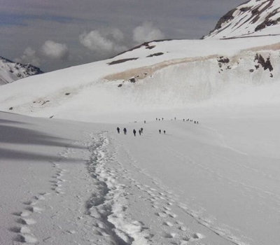
Today is the ‘D’ day of the trek and it is also the toughest and the longest day where the trekkers reach the destination Goechala at 15,100 feet and comes back to Lamuney. It is a long trek of 18kms and the approximate time to cover the distance is about 13 hours. The call for the day comes at 1 am in the morning. The reason to leave early is to have maximum time in hand for both ascend and descend. Also leaving early, hikers can enjoy the beautiful sight of sunrise in the Himalayas without which the trek would lose half of its charm. It is instructed to the travellers to keep the bags packed well in the night only so that after returning back to the campsite, the travellers can have lunch and leave for lower campsite, if time and weather permits.
After leaving the campsite it’s a known trail to begin with, towards Samiti Lake, which takes about an hour to reach. From here it’s a steep ascent of about 5 Km towards Goechala View Point. Usually it takes about 3 hours to climb the point but it entirely depends on the speed of the trekkers. From the Samiti Lake it’s a steep climb to the ridge which again should be travelled with much caution as its narrow and moves through the sides of the mountains. The beautiful sunrise in these awe striking snowy mountains is simply captivating. The glowing morning sun spreading its crimson colour on the dark snow creates magical effect which is so unique and breathtaking that words are insufficient to describe the exquisite scenery and the heartfelt pleasure to view the same. The other peaks spotted here from the top include Kabru South, Kabru North, Kabru Dome, Kangchendzonga, Gocha Jupano, Pandim, Sinvo and Tenzingkhang.
After spending some time at the View point and admiring the beauty at the most, descend to Lamuney at the earliest. On reaching the campsite at Lamuney cherish a hot lunch and pack the belongings for a further descend to the next campsite at Kokcharang.
Today, the trail remains mostly flat with small descents and ascents only to switch between mountains. Rhododendron trees line your way all along and the Prekchu flows below. Look left and at a number of places you get lovely views of Mt. Pandim and its neighbours. Phedang is 10 kms away and this is one of the longest trails between two known campsites. It takes about 4 hours to reach Phedang. From Phedang you retrace the descending trail to Tshoka. The days trek takes about 6-7 hours on an average.
Retrace your way from Tshoka to Yuksom. It’s much faster and easier than your trek up. Sachen comes up quickly being a pure descent. From Sachen the trail goes up and down generally losing altitude. The last stretch has a few climbs which make you wonder but it’s soon over and you find yourself back in the friendly Yuksom neighbourhood. Check-in guesthouse & take a good warm bath. In the evening, join Himalayan Memories team for a camp fire program.
After breakfast, checkout from hotel & get transferred to NJP or Bagdogra Airport by evening.
+91 7604030342 / 7604030349
hmdesk@himalayanmemories.com
