05 Nights / 06 Days
Moderate Trek
11,020 ft
Oct – May
West Sikkim
Melliaching
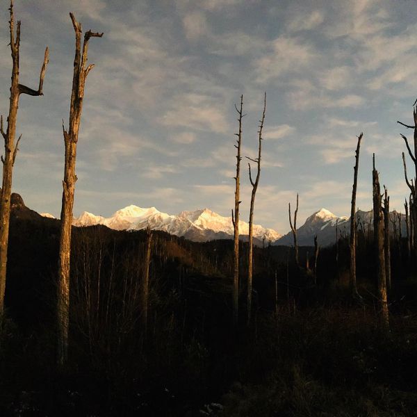
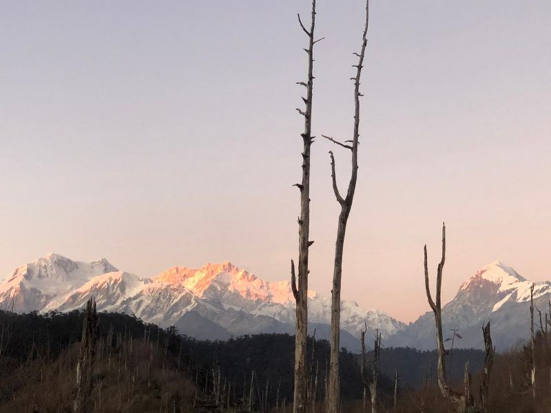
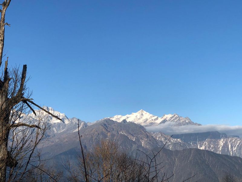
If new unexplored mountain trail is what fascinates you, then Bajre Dara trek in Sikkim should top your bucket list. Moreover, there aren’t many trekking trails in Sikkim, so this panoramic trail will surely be interesting to you. Kanchenjunga dominates the skyline of West Sikkim, so is on this trail. In fact the view from the campsite is breath-taking. On a clear day, you can see the snow-clad giants of Kangchenjunga massif, Kabru North, Kabru South, Pandim, Kumbhakarna along with some other peaks.
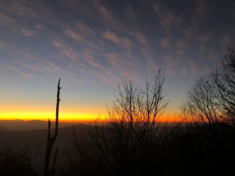
Few stories revolve around the nomenclature of this place. Dara in Nepali means Ridge. Bajre means the place where thunder strikes frequently. Years ago, a thunderbolt burnt out the vegetation of the place. You would find lots of burnt out, lifeless trees there, which seem to be quite haunting in the night amidst the ever-prevailing clouds. Another myth says that after the Kingdomship of Sikkim was usurped, the local people set that place in fire as a mark of faith and love for their King. Whatever be the reason for the nomenclature of the place, it’s unique in its own way.
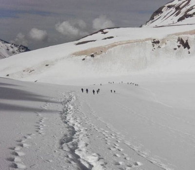
Though a small one, the trek is quite strenuous and you would have to make your way through a dense tropical rain forest infested with the infamous Himalayan Black Bear, the never-ending rainfall and leeches. The trek starts from Melliaching, a quaint village at 4300 ft, 18 Km away from Pelling town. There is quite a bit of climb around 6500 ft of altitude gain, split in two days of hike. Some parts of the hike include narrow and steep climbs around Gorujurey, where you might have to scramble to negotiate the slope. You will be trekking in a ridge having its top elevation at 11,020 ft. The trail is very slippery all through with a very little option for filling up your water bottle or unbuckling your sack for taking some rest. But, at the end of the day, its indeed a rewarding one.
The best part is that hardly people are aware of this trail. Most possibly you won’t come across any other group apart from your own team while hiking.
Best time for Bajre Dara trek:
Being in Eastern Himalayas (Sikkim/Nepal border) this area observes longer monsoon. Clouds start to hover from April and prolong till October beginning. There are two distinct seasons when this year trek is particularly beautiful:
1) Spring/Summer for Rhododendron season (Mar to May): From mid of March to Mid of May. Flowering starts from early March in the lower elevation, and gradually towards end of spring on higher altitude. Rhododendron and Giant Magnolia are two most famous along with several other wild flower species. Cloudy or misty atmosphere is common during Spring. Though clear mountains views are not uncommon, especially during morning.
2) Fall/Winter for clear weather (Oct to Feb): From mid-October to end of February. In the beginning of October clouds start moving out from this region and weather becomes clearer. November is particularly known for its crystal-clear views of the mountains.
Permit requirements for travelling and hiking in Sikkim:
If you are planning for extended holidays/destinations in Sikkim then check complete guide for permits requirements in Sikkim. Note that even Indians need Protected Area Permit (PAP)/Special permits for visiting entire North Sikkim/Nathu La etc. and parts of East and West Sikkim.
(A) For Indian National: No special permit is required for this tour. Carry an original Photo ID card with address proof on it (Aadhar/Driving Licence/Voter ID/Passport but NOT PAN CARD) & 2 photocopies of the same.
(B) For Foreign National including OCI: All foreigner (some relaxation to Nepalese and Bhutanese citizens) will require Inner Line Permit (ILP) which is recently renamed as Restricted Area Permit (RAP) to enter the boundary of Sikkim. This is issued Free Of Cost at Sikkim check posts while you enter Sikkim by road. This takes 15/20 minutes with the strength of your passport and valid Indian VISA. Overseas Citizens of India (OCI) has to go through the same process as of a foreign national.
Note: Diplomatic passport/ID card holders need to obtain a RAP/PAP directly applying to the “Ministry of External Affairs, Govt. Of India”, through their embassy/high commission channel.
https://www.sikkimtourism.gov.in/Public/TravellerEssentials/pap
Nationals of Pakistan, Myanmar, Nigeria and China can only apply for ILP/RAP through Ministry of Home Affairs, Government of India, New Delhi.
Do carry multiple copies (both hard and soft versions) of your recent passport size photo and photocopies of your documents (Passport/Visa/ILP) to avoid any showstopper on mountains!
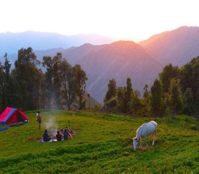
We heartily welcome you at Bagdogra Airport & take you to homes-stay at Melliaching. The motor road goes till the monastery located at the top of the ridge above the village. Overnight stay at Melliaching.
Trek Distance : 11 Kms || Time Taken: 9-10 hrs
Start from Melliaching & trek to Pangreytar (6,400 ft) for about 1.5 Km. From Pangreytar, we will gradually climb to a hump called Gorujorey of which the last half an hour is moderately steep. From this point we will descend to our next campsite Bhanjyang nestled inside the forest. Bhanjyang is at an altitude of around 7,382 ft. In between we come across a small hump called Goru Jurey which is about 8 – 9 km away & takes about 5 – 6 Hrs of steep hiking. Finally we camp at Bhanjyang.
Trek Distance: 10 Kms || Time Taken: 6 to 7 hrs
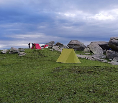
From Bhanjyang we have a moderate climb to Bajre Dara initially inside Rhododendrons and then through the bamboo forest. On a regular day it should take 6 to 7 hours to reach the campsite at Bajre Dara. Afternoon times can be often misty and foggy, especially in Sikkim/Eastern Himalayas. However, morning views are usually clear with splendid views of Kanchenjunga and surrounding snowy mountains. Overnight stay in tent.
Trek Distance: 16 Kms || Time Taken: 7-8 hrs
Dara in Nepali means Ridge. Bajre means the place where thunder strikes frequently. Remnants of thunder stricken, burnt out, dead tree trunks still stand on top of the ridge from which the name Bajre Dara comes from.
This ridge having its top elevation at ~ 3350 m/11020 ft. On the other side of the ridge you can see the foot shaped Khecheopalri lake, nestled into the rolling hills. This sacred lake is believed to be wish fulfilling one.
On a clear day, you can see the snow-clad giants of Kanchenjunga massif, Kabru North and South and Dome, Pandim, Kumbhakarna /Janu along with other peaks. You will see close views of Kanchenjunga and surrounding high mountains of Sikkim from Bajre Dara top and from many stretches of this pristine hiking trail.
Today, we start late & trek back to Pangreytar via Gorujurey. Total trek is for 16 km & is expected to take 6-8 hours. Camp for the night at Pangreytar.
Trek Distance: 3 Kms || Time Taken: 2 hrs ||Drive Distance: 25 Kms || Time Taken: 1 hr
Trek (3 Km) back to Melliaching via same route & then drive for about 2 hours to reach Pelling. Pelling is a small town in the northeastern Indian state of Sikkim, at the foothills of Mount Kanchenjunga. The late-17th-century Buddhist Sanga Choling Monastery has mountain views. Pemayangtse Monastery features wall paintings, sculptures and a gold-plated statue of Guru Padsambhava. Overlooking a valley, the 17th-century Rabdentse Palace, now in ruins, still has evidence of the king’s bedroom and kitchen.
Overnight stay in hotel at Pelling.
Drive Distance: 138 Kms || Time Taken: 7-8 hrs
Drive back to NJP/Bagdogra Airport.
+91 7604030342 / 7604030349
hmdesk@himalayanmemories.com
